Supporting Surveys and Reports
A number of supporting surveys and reports will be submitted alongside the formal application. Detailed below is a brief summary of the key reports:
Highways
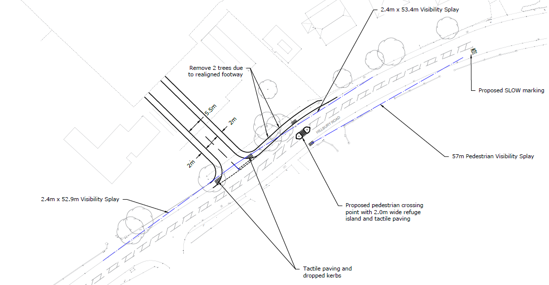
Access to the development site is proposed via a new junction at the southern extent of the site onto Hillbury Road between numbers 265 and 267 Hillbury Road. A separate pedestrian, cyclist and emergency access will be provided onto Shelton Close at the north-eastern corner of the site. This access arrangement was previously deemed acceptable by Surrey County Council under a previously withdrawn application (TA/2016/1895) which was for a 146 unit retirement village.
The provision of a simple priority junction is considered appropriate when taking into account the quantum of development proposed. The access road has been designed with a 5.5 metre wide carriageway with 6 metre junction radii to enable a car to pass a HGV or refuse vehicle. Visibility splays are provided in accordance with observed vehicle speeds past the site, recorded by way of an automatic traffic counter.
Junction capacity testing has been undertaken of the site access junction, demonstrating that the junction would remain comfortably within capacity during the weekday peak periods. Therefore there is no need for the junction to be upgraded beyond a simple priority junction.
Dropped kerbs and tactile paving will be provided at the access to accommodate passing pedestrian movements, whilst 2 metre footways will be accommodated alongside the access road providing pedestrians with safe access into the site.
The application will look to meet the parking guidance set out by Tandridge District Council.
Surface Drainage
Non Technical Summary
There are no watercourses or public surface water sewers in the immediate area so the rainfall that currently falls on the undeveloped site drains into the underlying soil as infiltration. If/when the land becomes saturated the extra surface water run-off overflows onto the opens fields to the north. It has been calculated that the existing 6.06 hectare site produces a rainfall rate of approximately 13 litres/second (Qbar) from its entire area.
The Development proposes to mimic this existing scenario by also using infiltration. The proposal is to capture all rainfall from the roads, houses and driveways using a new below ground piped network that will carry it towards the new detention basin along the northern boundary. A detention basin is a large grassy/planted depression approximately 1 metre deep with gentle 1in4 side slopes. The basin will remain dry during prolonged periods of dry weather and will only contain water after a rainfall event. The basin will empty by draining into the underlying chalk/soil using deep bored soakaways and the peak/maximum rate will be restricted to the existing rate of 13 litres/second.
The basin and drainage network will be sized to ensure all rainfall remains safely within the Development boundary for all extreme rainfall event up the 1in100 year return period, including an extra 40% allowance to account for climate change.
Foul Drainage
Non Technical Summary
The nearest usable public foul water sewer is located in Hillbury Road to the south, but the entire site falls a height of approximately 3.5 metres away from Hillbury in a northerly direction. Therefore, it will not be possible to use a gravity system to drain into the public sewer so a new adoptable foul pump station will be constructed in the north east corner, at the lowest point of the Development. Effluent from the new dwellings will be conveyed to the pump station using a new below ground piped network, which will then be pumped a distance of approximately 500 metres via a new rising main to the existing public sewer in Hillbury Road. The proposed foul sewers and pump station will be adopted by Thames Water under a S104 agreement to ensure they will maintained in perpetuity.
During Construction
It is anticipated that the scale of the construction works will not generate significant effects on flood risk, water quality or drainage system capacity. Standard mitigation measures to manage surface water run-off can be included in a Construction Environmental Management Plan (CEMP), secured through a planning condition.
Given the scale of the Proposed Development and its location within Flood Zone 1, the construction of the Proposed Development is considered unlikely to significantly affect flood risk, either in relation to the site itself or at offsite locations. A site-specific FLOOD Risk Assessment (FRA) and Drainage Strategy will be submitted in support of the planning application and this will describe and assess flood risk from all sources (i.e. from rivers, the sea, sewers and groundwater) to and from the Proposed Development and demonstrate how they will be managed, including an evaluation of climate change effects.
There will be demand for mains water during the demolition /construction works e.g. for damping down, but the volumes required are unlikely to lead to significant effects on potable water supply. Measures will be implemented by the contractor to ensure that water run-off is appropriately managed, to avoid uncontrolled use and contamination.
Operation
Relevant statutory authorities will be consulted to ensure that no significant effects arise from the Proposed Development with respects to potable water demand and wastewater discharges once operational. In addition, the proposed SuDs in the form of drainage ponds located across the site will ensure surface drainage will be maintained across the site whilst also providing ecological benefit.
Summary
As such, significant effects to water resources and flood risk are considered unlikely as the Proposed Development seeks to implement mitigation measures during construction and embed design measures which mitigation flood risk and drainage once operational.
Ecology
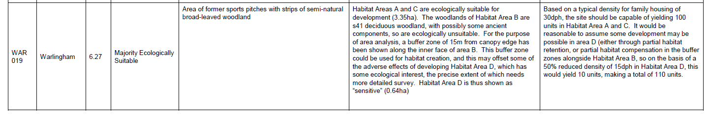
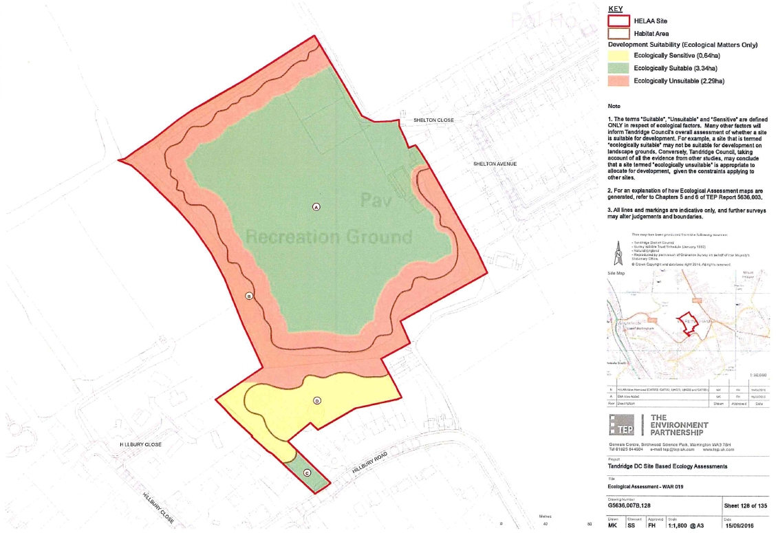
In September 2016 TDC commissioned ‘The Environment Partnership’ to undertake a report called ‘Site based ecology assessments – volume 1’. The report summarised the ecological findings of all 135 sites that Tandridge were considering for residential development as part of the new Local Plan. The report described the biodiversity on each site and identified the habitats of ecological interest and determined whether or not it was ‘ecologically suitable’ to be developed. The 2016 report concluded that this site was ‘majority ecologically suitable’ which meant that there were few features on site of ecological value (or where there appeared to be discreet areas of high value) that these the features on site could be readily protected during development.
The summary table from this report in relation to this site is shown below:
Following confirmation this this site could be sensitively developed Chartwell commission a number of ecology specialists to undertake the appropriate surveys so the appropriate strategy could be developed. All ecology reports and findings will be submitted as part of the application, however, the summary is that a small number of slow worms were found on the margins of the site. A dedicated ecology ‘wildlife zone’ will be incorporated within the proposed plans on the northern part of the site which will be created with tussocky grassland, scrub, log piles, and ‘hibernacula’ – rubble and logs covered in vegetation. The latter can be used by Slow Worms as a refuge, increasing the ‘carrying capacity’ for Slow Worms, and attracting a diverse range of invertebrates, that, in turn will benefit birds and bats. Managed in the long term as a grassland and scrub mosaic, ideally with scattered anthills, it will increase the biodiversity. It will look natural and attractive to the public with the grassland flora, rather than a less diverse and ornamental park-like landscape, or looking neglected. In addition to the terrestrial habitat the drainage area will provide wetland habitat to add to the diversity. The retention of tree lined margins will also create an ecological buffer on the parameter of the site which will also allow the free movement of creatures on site. Overall the site will benefit from a biodiversity nett gain on site in comparison to the existing.
Trees
The site is tree lined on all sides of the site on the former sports ground site. The dominant species on site is oak with a scattered population of ash, field maple and sycamore. A small number of the trees will be removed to form the link between the two sections of the site with the vast majority of the better quality boundary trees will be retained and have been provided with sufficient space to thrive and to continue to fulfil their role in screening the site and providing significant amenity to the local and wider area. New trees will be planted on site as part of a landscape plan.
Landscaping
A Landscape visual assessment (LVA) will accompany any planning application submission. The site has been selected out of hundreds considered by Tandridge and therefore has met the site visibility and landscape capacity test. One of the sites fantastic merits is the location to the village centre and public transport but most importantly its mature tree screening round the entire perimeter of the site meaning there will be little views into the site.
In October 2016 Tandridge commissioned Hankinson duckett Associates (hda) Landscape Architecture Masterplanning Ecology to undertake a Landscape Capacity and Sensivity Study of 135 sites that TDC were considering for the release for housing development. This report was considered through the Housing and Economic Land Availability Assessment (HELAA) and Economic Needs Assessment (ENA) process and concluded that this site was suitable for development in relation to site visibility and landscape capacity. Extracts from the 2016 report are below:
Site visibility
There is housing on three sides of the so the site and forms a natural extension to the existing settlement boundary. There is dense boundary vegetation around the perimeter and visual envelope of the site is limited to glimpses from the road and views from the houses along Hillbury Road which back onto the field.
There are views into the site from the public right of way (Footpath 110) The footpath will be retained and form part of the development proposals for nice walks for new homeowners and local residents to benefit from.
Overall the visual sensitivity is judged by Tandridge District Council to be ‘slight’.
Landscape Capacity
‘With slight sensitivity and value, It was confirmed by Tandridge through the course of their independent surveys and reports they commissions that the site is a relatively unconstrained site with a high landscape capacity for housing development, provided that the form of new development proposals are closely related to, and in scale with, existing settlement adjacent to the site.
Renewable Energy
The homes will be designed to be highly energy efficient incorporating well insulated rooms ensuring that internal temperatures are balanced all year round, preventing overheating in summer months and large heating bills in winter months. The homes will also include renewable energy technologies such as Air Source Heat Pumps and Solar Photovoltaics (PV) in order to minimise new homeowners energy bills.